Saturday, April 29, 2017

Motezuma's Castle

I have been remiss over the past few weeks. Our week together with our son, Scott, his wife Leigh, and our wonderful granddaughter, Julia in Sedona was jam packed. We went places, ate out, and generally had a great time.  I tried doing my work at night when we got back and that pretty much took care of my time.  On the following Saturday, we started heading east where we will be spending two months with my Mom in Clearwater.  The mileage has been extensive and then trying to work again in the evenings. Excuses, excuses, excuses! I will try to go back and pick up where we left off.

We met Scott, Leigh and Julia in Oak Creek about 7 miles outside Sedona for dinner.  They had flown into Phoenix, stopped by to see us at the RV and then driven to Sedona. It was a nice dinner with an early evening. OnSatuday, we moved to Rancho Sedona RV Park in Sedona to be closer to the kids. Sedona is breath taking.


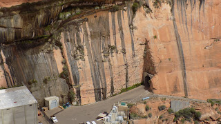
Saturday and  Sunday we just spent time together catching up. Monday we began our sight seeing with a visit to Montezuma's Castle National Monument. We found out that there were numerous Sinagua communities throughout the Verde Valley and this, like Tuzigoot,  was one.  However, the homes certainly looked different. Perched next to the Verde river was a community of 45 rooms high on a cliff side 100 feet up. The houses were built sometime between 1100 and 1300 AD.  The people were farmers, raising corn, squash, beans and cotton. The ruins were discovered by Spanish exploration in the 1400's but then went untouched for over 200 years. Early American settlers thought it was Aztec and thus the totally incorrect name, Montezuma's Castle. 


The apartments could only be accessed via ladders, now long gone. Over the years looters stole hundreds of artifacts.  In 1906, President Teddy Roosevelt, made Montezuma's Castle a National Monument. 

He was a president who had the foresight to save our history as opposed to the President who would be king along with his royal family.  Trump announced his latest executive order where he wants to remove national monument status from a number of monuments created by the last three presidents. The directive is part of a broader push to open up more federal lands to drilling, mining and other development. Another opportunity to put more money in the hands of his billionaire buddies like Tillerson and the Koch brothers while the man on the street gets shafted again. This was the man who proclaimed his commitment to preserving America’s “natural resources and beauty" during a speech on Earth Day. He went on to say, "Our Nation is blessed with abundant natural resources and awe-inspiring beauty. Americans are rightly grateful for these God-given gifts and have an obligation to safeguard them for future generations,”
“My Administration is committed to keeping our air and water clean, to preserving our forests, lakes, and open spaces, and to protecting endangered species,”. Oops, sorry, didn't mean that. 452 documented lies in 98 days. 

Next time, on to Jerome, AZ and the Grand Canyon.

Saturday, April 15, 2017

From the mountains to the desert floor

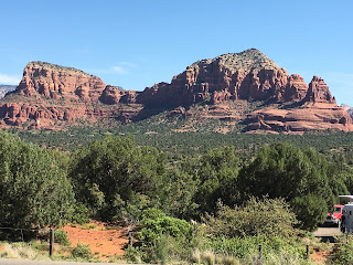
Our drive from Lake Powell to the Sedona area was another beautiful road trip. 55 miles down a two lane highway with only a dozen cars.  We took the inland route and never had to go over the the mountain with the incredible grade down to Black Springs.  We then moved into Navajo territory at The Gap.  Through Cameron and Gray Mountain into Flagstaff. We stopped for a moment so Jack could stretch his legs and he and I saw a whole family of wood chucks running in and out of their tunnels. We passed Wupatki National Monument and Sunset Crater Volcano National Monument.  Although we didn't have time to stop, we hope to do so on our way east.

Next on to 17 and up past Wilson mountain at 7,122 feet. You haven't lived until you are in an RV and you see a sign that says, "6% downgrade next 18 miles." 18 miles-we had never seen anything like it. Signs kept appearing saying, "Save your brakes! 12 miles to go".  We saw one tractor trailer on the side of the road with his brakes smoking. We sort of figured out how to take our RV and tow dolly down mountains and didn't have any problems.

We reached Distant Drums RV park in Camp Verde in the middle of the Verde Valley.  Warmer than the high mountains we came from and cooler than Phoenix down the road.  Mountains, deserts, ghost towns, and five national parks or monuments within 1 hour drive. We wanted to stay in Sedona but apparently snow birds come to Arizona as well as Florida. Even a month in advance we could only get a reservation from the 16th to the 22nd. Not a day early or a day later. Our son Scott, his wife Leigh and our 9 year old granddaughter, Julia, flew into Phoenix today and are driving to Sedona.  It's Julia's spring break and we met them last year in Santa Barbara. So, we ended up in Camp Verde, but even here things are busy. There are 157 spaces at this camp and they are full. We are finding that more and more whenever we want to stay near a national park or a destination city.  So many people on the road. 

The day after getting set up, we went over to Costco and Trader Joe's for basics and fun.  Just like home, except the closest one is in Prescott, 35 miles away. I love driving the road here. Big open spaces, good roads, beautiful wild flowers and more open space.

Next we headed to Tuzigoot National Monument just beyond Cottonwood.  More about Cottonwood next time, but for now, it was a cowboy town and home to bootleggers during prohibition. Tuzigoot is the remnant of a Southern Sinagua village built between 1000 and 1400.  It was a multiple family pueblo high atop a long ridge rising 120' above the Verde valley. The original pueblo was two stories high in some places and 87 rooms. At it's height, over 200 people lived here. No one knows why they left but by the early 1400's, they were gone.  


 And look, my favorite person at the top.

Thursday, April 13, 2017

Lee's Ferry/Navajo Bridge/Horseshoe Bend

If you like the blog, why not subscribe for direct delivery into you email box.  Just go to the bottom of the page, enter your email address and click on "subscribe".

Saturday and Sunday at Lake Powell turned out to be really great days. On Saturday, we headed to Lee's Ferry. You drive about 22 miles directly south of our campsite and then make a 180 degree turn back north and slightly west for 30+ miles and you arrive at the Navajo bridge across the Colorado river. The location is actually 10 miles south and 5 miles west of the campsite as the crow flies, but there are just no roads to get there. The road south takes you up a mountain onto a plateau for several miles and then a 6% downgrade from the plateau and onto the road that turns back and travels along the mountain you just came down.

Next you arrive at the Navajo Interpretive Center right next to the Navajo bridge. The new bridge (built in 1995) replaced the original bridge (built in 1929) which is now used as a pedestrian bridge. The first bridge replaced Lee's Ferry (more in a few minutes).  


 On to Lee's Ferry. In an effort to provide access for Mormon expansion into Arizona, the church sent a ferry operator names John D. Lee to a remote outpost at the junction of the Colorado and Paria Rivers. The rivers create a short interruption in the canyon walls by separating the geologic features of Glen and Marble Canyons. This was the only location for hundreds of miles in either direction where the canyon walls go from violently sheer to mildly slopping. This enabled wagons and livestock to make it to the river's edge. In 1873, the ferry opened for business. The ferry was loaded, dragged upstream by ropes and then pushed out into the current to carry it to the other side. As you can imagine, it was not the safest crossing known to man. Property, life and even the ferry were periodically swept downstream. When the travelers made it to the other side, they had a long, arduous haul out of the canyon. The main road out, Lee's backbone, was steep with uneven climbs and drops of over 350'. But, the ferry operated for 55 years carrying pioneers on spiritual missions, surveyors looking to erase the word "unexplored" from their maps, native Americans trying to understand a new world, and even outlaws. The last trip took place in 1928 when, carrying three passengers and a model T Ford, the ferry capsized, the passengers and crew drowned and their bodies were never recovered. 


 On the way to the crossing, you pass the vermilion cliffs and sites to take your breath away.


Further down the road, we found a place called cliff dwellers where people had converted fallen rocks into homes. We still don't know who they were or when the homes were built, but they look pretty recent. Perhaps they were hippies who stopped along the way to California.


Then the long ride back and an early start the next day to Horseshoe Bend. Just five miles south of our campsite is the place where the river turns back on itself and creates an incredible sight. You hike only 1.5 miles but the walk up takes some stamina because at the end is an overlook, 1,000 feet above the river and the canyons. 


The walk back was just as challenging but the hike was worth it.  We said goodbye to one of the neatest places we have been yet.


Wednesday, April 12, 2017

Glen Canyon National Recreation Area

We've been off the grid for several days while at Glen Canyon National Recreation Area, better known as Lake Powell.  The internet reception was terrible even with a hot spot and cell phone booster. But it was worth it. The drive from Utah over the mountains and into the Lake Powell area was fantastic. Around every turn, something beautiful popped up.


And then we came to the gates of Glen Canyon National Recreation Area. I didn't think we were in the right place, but the ranger at the gate told us to head down the road about a mile. We kept getting closer and closer to the lake. Next came the office and registration. We were at the right place, Wahweap Marina campground. More breathtaking views.


This was one of the best campgrounds so far. Not only beautiful but also one of the most well run and well outfitted.  Concrete, level pads. Superior utility connections. Picnic tables, individual barbecue grills, and fire pits. Walking paths with great access for dogs and, oh yea, jack rabbits. The sky can only be described as brilliant. The closest town is Page, AZ with a population of only 8,000 that doesn't produce ambient light.  Nothing but stars!!

Friday we headed to the Glen Canyon dam and had a guided tour through the facility. This was the last of the big dams on the Colorado.  The dam was started in 1956 when Ike pressed the button in DC that started the first explosion for the dam.  It was finished in 1966 but then took until 1980 to back fill the lake. The dam is 710' high and provides an equitable water distribution to Colorado, Wyoming, most of New Mexico and the lower basin of Nevada, California and Arizona. In addition, the dam provides hydroelectric power to the point that they produce more electricity than demand.  There were so many construction workers that the town of Page had to be constructed and the bridge across the canyon completed before they built the dam.


Every day something great!