So, we went back to Capitol Reef National Park for a second day and boy, was it worth it. First, we drove by Chimney Rock
Next we went to Panorama Point and, more importantly, the Goosenecks. Down a gravel road and then up a steep path to the top of an 800' canyon over the Fremont River.
Is that cool or what?
Next we decided to go for a hike to the Hickman Natural Bridge. It seemed like a pretty easy hike only 1 mile in and 1 mile out. What we didn't know was that it was 400' up over that 1 mile. That's equal to climbing up a 40 story building. We did it but it sure took longer than we thought. The view along the way was pretty good.
Capitol Reef turned out to be one of our favorite parks so far. The colors, the shapes, the different geology, the history of the people whether the ancestral Indians, the more recent Ute and Paiute tribes, the Mormon settlers who became a self sufficient community in the shadow of the cliffs-all of it was so impressive. 280 million years of climate change, a tectonic shift that pushed the western side of the split more than 7,000' into the air, storms, flash floods, and erosion created 378 square miles of wonder.
If you like the blog, you can subscribe for direct delivery into your email box immediately after being published. Go to the bottom of the page, enter your email address and press subscribe. Easy as pie from the Gifford House bakery.
We spent several days in Torrey, UT, the closest town to Capitol Reef National Park. This was the third of the Mighty 5 National Parks of Southern, Utah. And, what a place it is. This park is right up there with Yosemite. The park is in a mountainous area of Utah. Different parts of the park have different appearances. Located in the park is Capitol Dome, so named because early travelers thought it reminded them of the capitol due to its shape and color. That led to the naming of the Park.
It took 65 million years of erosion, flooding, and constant water dripping to create the park's incredible beauty. Water made the entire park.
We spent two days in the park with the first day spent driving the scenic route and making several stops along the way.
We drove over hills and mountains, into canyons, down washes, and looked at arches, hoodoos, and gullys. It is really hard to grasp the size and height of these cliffs that are truly sculptures across the sky. For example, the photo above is at least 150' tall from the base to the top. Add the hill that it is on and you can understand why it is so awe inspiring. The different colors are breathtaking.
And, at the end of road, the Gifford House where you can get all types of fresh baked goods, home made ice cream, home made preserves, relishes, and pickles along with handmade aprons, pot holders, and you name it.
Who could ask for more?
Tomorrow, more parts of the park.
We are here in Moab, UT and within 30 miles of two amazing National Parks, Canyonlands and The Arches. Utah has 11 National Parks, Monuments and Historic Sites and five of the parks in the South are called The Mighty Five. (Canyonlands, Arches, Capital Reef, Bryce Canyon and Zion). Over the last few days, we visited Canyonlands and The Arches.
Canyonlands is called, "A Wilderness of Rock". The rock was cut into flat layers of sedentary rock that resulted in hundreds of canyons, mesas, buttes, fins, arches and spires. There are two major canyons carved by the Green and Colorado Rivers. There are three separate areas separated by miles. Island in the Sky, The Maze and The Needles. Only Island in the Sky is really accessible by two wheel drive car. So, that's where we went. Lots of different view points of canyons.
Guess who the person is taking the picture of me at Grandview Overlook?
Candlestick Tower.
Orange Cliff overlook.
And then, a climb to the top of Upheaval Dome.
To see this.....
The prevailing theory is that it was created by a giant meteor thousands of years ago.
Then on the way out....
Navajo Cliffs
Yesterday, we spent hours at Arches National Park. Calling it amazing is an understatement. It is absolutely unworldly.
The photos speak for themselves.
Balanced Rock...
Courthouse Towers.....
Delicate Arch....
Devil's Garden....
Fiery Furnace....
Windows Arch....
Sand Dune Arch.....
Skyline Arch.....
What a great day!!
Tomorrow on to Torrey, UT and Capital Reef National Park.
We stayed the night in the four corners region of New Mexico and then headed to Utah. We traveled through several Native American nations including the Navajo Nation. We saw rows upon rows of high buttes where in our minds we saw hundreds of warriors. Of course, no such thing in reality. The reservation is modern with good community services. The scenery went on forever.
On that one day, we drove through New Mexico, Colorado, and Utah. We were heading to Moab and saw this amazing pillar.
It absolutely looked man made, but in fact, it was wind made. It was at least 40' high. And then , thirty five miles down the road, Spanish Trails RV Park. Our home is the silver one.
We found our pot of gold when the fun began with visits to Canyonlands and Arches National Parks. Photos tomorrow.
After leaving Amarillo, we headed west into New Mexico. The beginning of New Mexico was just like the ending of Texas. Big open spaces, with very little indication of people. We stopped for breakfast in Tucumcari, NM. A town that only existed as a stopping place on old Route 66. At one time, this town boasted over 2,000 hotels and with all the associated restaurants, souvenir shops, and bars. When Interstate 40 replaced Route 66, the town simply rolled up and died. But you can still see the vestiges of what it was. Some independent motels are still in business, a few restaurants remain open and lots of evidence of art deco gas stations, trading posts, and every other kind of business you can imagine. We did find Kix Coffee Shop still serving coffee and breakfast every day where we had a great breakfast.

Then, on to Albuquerque. A surprising city that is modern with dozens of recognizable corporations, medical facilities, trendy restaurants, and shopping to beat the band. But, it is also a sprawling city in the high desert with magnificent cactus, flowers, and a striking landscape. But, as modern as it is, there is a great connection to history. That is the history of the mother road. Route 66 ran right through Albuquerque. You know the song, Joplin, MO, Oklahoma City, Gallup, NM.
We stayed at Enchanted Trails RV Park. An RV park that has been in business for 45 years. Before that, it was one of those Trading Posts that sold all kinds of souvenirs, Indian goods, and where the owners even dressed up as Indians to promote the store. The business was started in the 1940's and continued until Interstate 40 replaced Route 66 in the 1970's.
The park celebrates it's history with several restored trailers and cars from the 40's to 60's. You can rent one for a break from the regular. There were also old televisions, music machines, and other memorabilia from the 40's to the 60's.
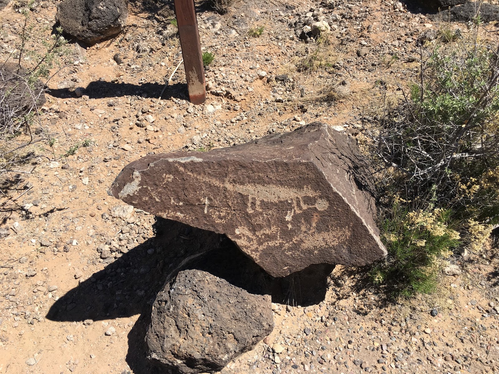
 The day before we left, we visited Petroglyph National Monument. Located in the middle of a suburban neighborhood are three different sites that contain literally hundreds of Indian carvings. The site we visited was a high hill that was a tough climb over rocky trails. Clear carvings on the way up and down and a great view at the top.
Now, on to Utah.